


Extreme Makeovers: How Land Reclamation Transformed Our Offshore Islands
You might have read about the Pulau Tekong land reclamation project, which aims to create more reclaimed land for military training purposes, freeing up space on the mainland for other uses like developing homes and other amenities.
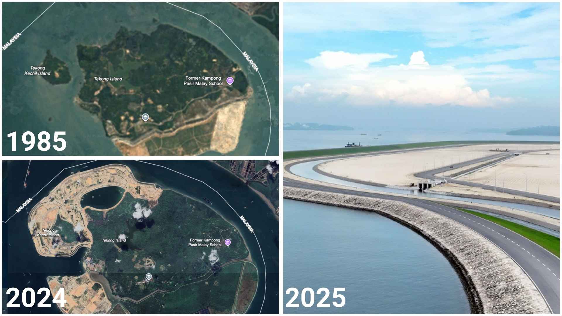
As of Monday (8 September 2025), the reclamation project has been completed, adding about 800 hectares of land at the tip of the Pulau Tekong island off its northeastern coast. That's approximately the size of two Toa Payoh towns!
The newly reclaimed land will be used to conduct specialised training exercises such as amphibious training and heliborne training. It will also see the construction of urban training facilities and an enhanced BMT field camp site.
In addition, this project is especially notable as it marks Singapore's first completed polder project, where land below mean sea level is reclaimed, reducing the amount of sand used for reclamation by almost 50%. (The area is protected by a 10km coastal dike, which can be raised to adapt to rising sea levels.)
This is far from the first time that Pulau Tekong has undergone land reclamation. In fact, the island used to be made up of two separate islands: The 2,442.6-hectare Pulau Tekong Besar, and the 89-hectare Pulau Tekong Kechil. Initial land reclamation works in the 1990s joined the two islands, creating Singapore's largest offshore island to date.
Of course, Singapore has a long history of land reclamation projects to make the most of our limited land space. Here are some other offshore islands that have undergone land reclamation over the years.

IMAGES: GOOGLE EARTH
From seven islands to one industrial powerhouse: Jurong Island
How it started: Jurong Island was once an archipelago of 7 southwestern islands – Pulau Merlimau, Pulau Ayer Chawan, Pulau Ayer Merbau, Pulau Seraya, Pulau Sakra, Pulau Pesek and Pulau Pesek Kecil.
Reclamation 101: Land reclamation works for Jurong Island began in 1995, aiming to merge the aforementioned islands into a single large island. While the project aimed for a 2030 completion date, it ended up finishing in 2009, 20 years ahead of schedule.
The island today: Jurong Island is now a major petroleum and petrochemicals hub, making it the heart of Singapore's chemical and energy industry. IMAGES: GOOGLE EARTH
Oil, islands, and industrial might: Pulau Bukom, Pulau Busing and Pulau Ular
How it started: You probably won't have heard of any of these islands unless you work in the oil and petrochemicals industry.
Back in the day, there were a total of four unconnected islands: namely, Pulau Bukom Besar, Pulau Bukom Kechil, Pulau Ular, and Pulau Busing.
Pulau Bukom Besar was the most notable of the four, being the site of Singapore's first oil refinery in 1961. It also had around 5000 residents, mostly employees of petrol company Shell, and their family members. Aside from housing, the island had a few other amenities such as chapels, a mosque, two schools and even an open-air cinema.
Reclamation 101: Due to continued expansion of the refinery complex on Pulau Bukom Besar, land reclamation options began to be explored.
An initial plan to merge Pulau Bukom Besar and Pulau Bukom Kechil by filling the channel between them was found to be too expensive and thus discarded. Instead, the hills on Pulau Bukom Besar and Pulau Bukom Kechil were levelled in the early 1970s to provide materials to reclaim the surrounding seabed.
Most notably, Pulau Ular, which was originally just a submerged reef with two visible islets, underwent major land reclamation from 1974 to 1980, becoming a 30-hectare island linked to Pulau Bukom Besar by bridge.
By 1995, the "Besar" was dropped from Pulau Bukom Besar's name, making it merely Pulau Bukom. As for Pulau Bukom Kechil, it would eventually cease to exist after being merged with Pulau Busing and Pulau Ular into a single island in 2005.
The islands today: Pulau Bukom and Pulau Busing/Ular jointly make up Shell's integrated petrochemical complex, which is also linked to the facilities on Jurong Island via subsea pipelines.

IMAGES: GOOGLE EARTH
More than just a landfill: Pulau Semakau
How it started: The island we now know as Pulau Semakau used to be two separate islands: one with the same name as the current island, and a second island called Pulau Seking (also known as Pulau Sakeng or Siking).
The original Pulau Semakau was once home to a Malay village on the western side of the island and a small Chinese village at the southwestern end. Meanwhile, Pulau Seking measured approximately 500m by 200m (the size of about 10 football fields) and was home to islanders who considered themselves Orang Selat ("people of the straits").
Reclamation 101: As Singapore's two landfills in Lim Chu Kang and Lorong Halus were projected to reach full capacity by the late 1990s, the decision was made to create an offshore landfill site due to land constraints on the mainland.
Reclamation works began in 1995 through building a 7-kilometre long rock bund to connect Pulau Seking and Pulau Semakau. The bund enclosed the waters around the proposed landfill site, creating a total landfill area of 350 ha, and a land capacity of 63 million cubic metres.
The island today: Despite being best known for serving as Singapore's first and only offshore landfill, there's more to Pulau Semakau than just rubbish. In fact, the island and the waters surrounding it are home to a rich marine ecosystem teeming with wildlife such as sea anemones, barracuda, and birds like the endangered great-billed heron.
It's also open to visitors for recreational activities such as nature walks, birdwatching, stargazing, and recreational fishing. The landfill area itself is out of bounds though (not that you would want to go there in the first place).

IMAGES: GOOGLE EARTH
Cats, clear waters, and forgotten histories: St John's Island, Lazarus Island and Pulau Seringat
How it started: St John's island has been used for various different purposes over the years, from a quarantine facility for communicable diseases (with those who died from said diseases being buried on nearby Lazarus Island) to a detention centre for political prisoners and members of secret societies, an opium treatment centre, and even temporary housing for Vietnamese refugees in 1975.
Reclamation 101: In the 1980s, the Singapore Tourism Promotion Board (now known as the Singapore Tourism Board) began to develop the Southern Islands into a holiday resort.
As part of the redevelopment, Pulau Seringat and Lazarus Island were connected by a sandbar, while walkways were built to link St John's Island and the expanded Lazarus Island. Construction and land reclamation of the islands were completed in 2006.
The islands today: St John's Island is well known for being a cat paradise, with the island's furry inhabitants taken care of by volunteers who make regular visits to the island.
Meanwhile, Lazarus Island is a tranquil, picturesque paradise with pristine beaches and crystal-clear waters. You're not likely to see crowds here either, making it perfect for a getaway, albeit with one caveat: The island lacks amenities of any sort, including toilets (hence the lack of crowds).
As of 2024, there have also been plans to collectively designate the southern part of Lazarus Island and the reef off Kusu Island as Singapore's second marine park, following in the footsteps of Sisters' Island Marine Park.
 IMAGES: GOOGLE EARTH
The rustic escape that almost wasn't: Coney Island
How it started: This island has had several different names over the years, from its original name of Pulau Serangoon to Haw Par Island in the 1930s to 1940s, when it was owned by brothers Aw Boon Haw and Aw Boon Par of Tiger Balm fame. In fact, the 600-square-metre bungalow constructed by the brothers still stands today, and is known as the Haw Par Beach Villa (not to be confused with everyone's favourite scary amusement park Haw Par Villa).
The 1950s saw a businessman purchase Pulau Serangoon from the brothers, attempting to develop it into a leisure resort called Singapore Coney Island. However, despite the presence of a dance hall, a restaurant and bar, as well as seaside accommodation, the planned leisure resort failed to take off, resulting in the island being put up for auction.
After changing hands a few times, Coney Island, as it was now popularly known, was eventually bought back by the Singapore government in 1972.
Fun fact: Before the name "Coney Island" became associated with Pulau Serangoon, Coney Island also referred to Pulau Satumu, a different offshore island in the southwest of Singapore where Raffles Lighthouse is located.
Reclamation 101: In 1975, land reclamation began on Coney Island, turning it from a mere 13-hectare land mass to an island spanning around 154 hectares.
The initial plans aimed to develop Coney Island into a recreational destination (again) with chalets, a beach and a marina for pleasure boats. However, said plans were indefinitely shelved (possibly at least in part due to the pungent smells from pig farms in nearby Punggol wafting over to the island).
Additional reclamation plans were proposed in the 1980s to connect Coney Island to the mainland. These plans were likewise scrapped due to opposition from the public, with many feeling that it would rob the island of its natural charm.
Ultimately, Coney Island underwent another round of reclamation work in the 1990s to extend the southern part of the island as part of the Punggol 21 plan, which aimed to redevelop the Punggol area into a waterfront town. A 50-hectare nature park was built on Coney Island, and the southern portion of Coney Island was reserved for residential purposes, although plans to develop housing in the area were subsequently scrapped.
The reclamation works saw the channel separating Coney Island and Punggol narrow from 200m to 100m, with this body of water, along with part of Sungei Serangoon, being converted into Serangoon Reservoir in 2007.
The island today: After years of gestation, Coney Island Park was officially opened to the public on 10 October 2015, featuring a 2km-long beach, a boardwalk, and basic amenities like toilets.
To retain the island's rustic feel and charm, its natural ecosystems such as the rich mangrove swamps, coastal forests, and wetlands were preserved. The new additions? Environmentally friendly features like toilets that use rainwater and solar-powered water pumps, as well as benches and boardwalks that are made by recycling timber from uprooted trees.
Access to Coney Island is available through two bridges on either end of the island: One that leads to Punggol, and another that leads to Pasir Ris Coast Industrial Park. Neither electricity nor piped water is available on the island, and it closes at 7 pm daily due to the lack of artificial lighting.
 IMAGES: GOOGLE EARTH
Staycation island with a storied history: Sentosa
How it started: Historically known as Pulau Blakang Mati, the old Sentosa is probably best known for being the site of a military installation with artillery batteries during the colonial era. Forts Siloso and Serapong were converted for use by the Catholic and Protestant churches respectively after WWII, while Fort Connaught was left disused.
The island fully came under independent Singapore's jurisdiction in 1967, and a contest to rename it was held in 1969, with the name Sentosa, meaning "tranquillity" in Malay, being chosen as the winning entry.
A multimillion dollar plan to develop Sentosa into a resort destination was unveiled in the early 1970s. By 1974, the cable car system and Sentosa Golf Club had opened, with more attractions to follow in the years to come.
Reclamation 101: Land reclamation efforts on Sentosa started from 1979 to 1980, where Sarong Island and Pulau Selegu were reclaimed and merged into its land mass. The islet Buran Darat was the next in line as part of a reclamation project that finished in 1994, eventually becoming the land on which Sentosa Cove now sits. Out of the total of 117 hectares that makes up Sentosa Cove, 100 hectares of its land is reclaimed.
And, of course, Sentosa's famous beaches – Palawan Beach, Siloso Beach and Tanjong Beach – are artificial beaches that consist of reclaimed land.
The island today: Over the years, Sentosa has grown from an initial size of about 280 hectares to a massive island spanning over 500 hectares.
It has just about everything, from beaches to a integrated resort, a skydiving simulator, a floating obstacle course, kart racing, a wax museum, Luge tracks, and much, much more. The old military forts are still standing, though only Fort Siloso is open to the public.
For the latest updates on Wonderwall.sg, be sure to follow us on TikTok, Telegram, Instagram, and Facebook. If you have a story idea for us, email us at [email protected].


